Back Waikerie CEB وایکری، استرالیای جنوبی Persian Waikerie Malagasy Waikerie Polish Waikerie Swedish ویکیری، جنوبی آسٹریلیا Urdu
| Waikerie South Australia | |
|---|---|
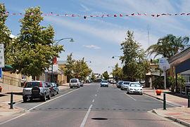
 McCoy street, the main street of Waikerie | |
| Coordinates | 34°10′0″S 139°59′0″E / 34.16667°S 139.98333°E |
| Population | 1,670 (UCL 2021)[1] |
| Postcode(s) | 5330 |
| Location | |
| LGA(s) | District Council of Loxton Waikerie |
| State electorate(s) | Chaffey |
| Federal division(s) | Barker |
Waikerie (/ˈweɪkəri/ WAY-kə-ree ) is a rural town in the Riverland region of South Australia on the south bank of the Murray River. At the 2016 census, Waikerie had a population of 2,684.[2] The Sturt Highway passes to the south of the town at the top of the cliffs. There is a cable ferry crossing the river to provide vehicle access from the north side of the river. Waikerie is known for citrus growing, along with stone fruit and grapes.
- ^ Australian Bureau of Statistics (28 June 2022). "Waikerie (urban centre and locality)". Australian Census 2021.
- ^ Australian Bureau of Statistics (27 June 2017). "Waikerie (State Suburb)". 2016 Census QuickStats. Retrieved 25 January 2018.
