Back نیروگاه وایراکی Persian Centrale géothermique de Wairakei French 와이라케이 발전소 Korean Wairakei kraftverk NB Elektrownia Wairakei Polish ГТЕС Ваїракеї Ukrainian
| Wairakei Power Station | |
|---|---|
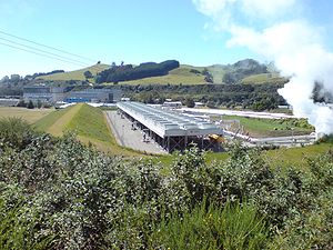
 The Wairakei Power Station, with the main two blocks at the left rear. The binary plant is in front. | |
 | |
| Country | New Zealand |
| Location | Wairakei, north of Taupō |
| Coordinates | 38°37′37″S 176°06′19″E / 38.62694°S 176.10528°E |
| Status | Operational |
| Commission date | November 1958 |
| Owner | Contact Energy |
| Geothermal power station | |
| Type | Flash steam with binary cycle[1] |
| Wells | 55 production 6 reinjection 50 monitoring[1] |
| Max. well depth | 660 m (2,170 ft)[1] |
| Power generation | |
| Units operational | 6× 11.2 MW 3× 30 MW 1× 4 MW 1×14 MW binary |
| Nameplate capacity | 175 MW |
| Capacity factor | 89.0% |
| Annual net output | 1365 GWh[1] |
| External links | |
| Commons | Related media on Commons |
The Wairakei Power Station is a geothermal power station near the Wairakei Geothermal Field in New Zealand. Wairakei lies in the Taupō Volcanic Zone.