Back Walfer ALS Вальферданж Byelorussian Вальфэрданж BE-X-OLD Walferdange Catalan Walferdange (munisipyo) CEB Walferdange Czech Walferdange Danish Walferdingen German Walferdange Spanish والفردانژ Persian
Walferdange
Walfer (Luxembourgish) | |
|---|---|
 View from Sonnebierg | |
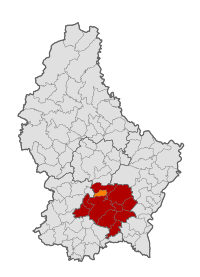
 Map of Luxembourg with Walferdange highlighted in orange, and the canton in dark red | |
| Coordinates: 49°39′46″N 6°08′00″E / 49.6628°N 6.1333°E | |
| Country | |
| Canton | Luxembourg |
| Government | |
| • Mayor | François Sauber (CSV) |
| Area | |
| • Total | 7.06 km2 (2.73 sq mi) |
| • Rank | 100th of 100 |
| Highest elevation | 405 m (1,329 ft) |
| • Rank | 46th of 100 |
| Lowest elevation | 228 m (748 ft) |
| • Rank | 41st of 100 |
| Population (2023)[2] | |
| • Total | 8,730 |
| • Rank | 16th of 100 |
| • Density | 1,200/km2 (3,200/sq mi) |
| • Rank | 6th of 100 |
| Time zone | UTC+1 (CET) |
| • Summer (DST) | UTC+2 (CEST) |
| LAU 2 | LU0000310 |
| Website | walfer.lu |
Walferdange (Luxembourgish: Walfer [ˈvɑlfɐ] ; German: Walferdingen) is a commune and small town in central Luxembourg.
- ^ "WALFERDANGE - Syvicol". www.syvicol.lu. Retrieved 3 April 2019.
- ^ "Table view". statistiques.public.lu. Statec. Retrieved 3 April 2018.
