Back وور Arabic وور ARZ وار، باتی ویرجینیا AZB War (Virgínia de l'Oest) Catalan Вор (Малхбузен Вирджини) CE War (lungsod) CEB War, Gorllewin Virginia Welsh War (Virginia Occidental) Spanish War (Mendebaldeko Virginia) Basque ور، ویرجینیای غربی Persian
War, West Virginia | |
|---|---|
 | |
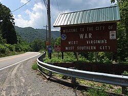
| Nickname: West Virginia's most southern city | |
 Location of War in McDowell County, West Virginia. | |
Location in the State of West Virginia | |
| Coordinates: 37°18′4″N 81°41′3″W / 37.30111°N 81.68417°W | |
| Country | United States |
| State | West Virginia |
| County | McDowell |
| Named for | War Creek |
| Government | |
| • Mayor | Thomas Hatcher[1] |
| Area | |
| • Total | 0.92 sq mi (2.38 km2) |
| • Land | 0.89 sq mi (2.31 km2) |
| • Water | 0.03 sq mi (0.08 km2) |
| Elevation | 1,342 ft (409 m) |
| Population | |
| • Total | 690 |
| • Estimate (2019)[3] | 662 |
| • Density | 768.80/sq mi (296.85/km2) |
| Time zone | UTC-5 (EST) |
| • Summer (DST) | UTC-4 (EDT) |
| ZIP code | 24892 |
| Area code | 304 |
| FIPS code | 54-84484[4] |
| GNIS feature ID | 1555916[5] |
| Website | local |
War is a city in McDowell County, West Virginia, United States. The population was 690 at the 2020 census.[3] War was incorporated in 1920 by the Circuit Court of McDowell County. Its name is derived from War Creek,[6] whose confluence with Dry Fork is located within the city. War is the only place in the United States with this name. War was formerly known as Miner's City.
- ^ "Elected Officials". State of West Virginia. Retrieved May 14, 2024.
- ^ "2019 U.S. Gazetteer Files". United States Census Bureau. Retrieved August 7, 2020.
- ^ a b c "City and Town Population Totals: 2020-2021". Census.gov. US Census Bureau. Retrieved July 3, 2022.
- ^ "U.S. Census website". United States Census Bureau. Retrieved January 31, 2008.
- ^ U.S. Geological Survey Geographic Names Information System: War, West Virginia
- ^ Capace, Nancy (1999). Encyclopedia of West Virginia. North American Book Dist LLC. p. 195. ISBN 978-0-403-09843-9.
