Back Warrumbungle Shire CEB Warrumbungle Shire German Comté de Warrumbungle French Contea di Warrumbungle Italian Warrumbungle Shire Council Dutch Warrumbungle Shire Swedish
| Warrumbungle Shire New South Wales | |||||||||||||||
|---|---|---|---|---|---|---|---|---|---|---|---|---|---|---|---|
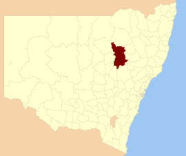
 Location in New South Wales | |||||||||||||||
| Coordinates | 31°15′S 149°16′E / 31.250°S 149.267°E | ||||||||||||||
| Population |
| ||||||||||||||
| • Density | 0.7580/km2 (1.9632/sq mi) | ||||||||||||||
| Established | 2004 | ||||||||||||||
| Area | 12,380 km2 (4,779.9 sq mi) | ||||||||||||||
| Mayor | Denis Todd (Unaligned) | ||||||||||||||
| Council seat | Coonabarabran[3] | ||||||||||||||
| Region | Orana | ||||||||||||||
| State electorate(s) | Barwon | ||||||||||||||
| Federal division(s) | Parkes | ||||||||||||||
 | |||||||||||||||
| Website | Warrumbungle Shire | ||||||||||||||
| |||||||||||||||
The Warrumbungle Shire is a local government area in the central western region of New South Wales, Australia. The Shire is traversed by the Newell Highway. The Warrumbungle mountain range and Warrumbungles National Park are major tourist attractions for the Shire. Its seat is located in Coonabarabran, a town in the southwest.
The mayor of Warrumbungle Shire Council is Cr. Denis Todd, who is unaligned with any political party.
- ^ Australian Bureau of Statistics (27 June 2017). "Warrumbungle Shire (A)". 2016 Census QuickStats. Retrieved 7 July 2017.
- ^ "3218.0 – Regional Population Growth, Australia, 2017-18". Australian Bureau of Statistics. 27 March 2019. Retrieved 27 March 2019. Estimated resident population (ERP) at 30 June 2018.
- ^ "Warrumbungle Shire Council". Division of Local Government. Retrieved 2 December 2006.