Back نهر واتوغا Arabic نهر واتوجا ARZ Watauga River (suba sa Tinipong Bansa, lat 36,45, long -82,42) CEB Watauga River German Watauga (rivière) French Watauga River Polish
| Watauga River Watoga[1] | |
|---|---|
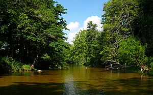
 The Watauga River near Valle Crucis, North Carolina | |
 Locator – overview | |
| Etymology | Native American |
| Location | |
| Country | United States |
| States | North Carolina, Tennessee |
| Counties | Avery NC, Watauga NC, Johnson TN, Carter TN, Sullivan TN, Washington TN |
| Physical characteristics | |
| Source | Linville Gap[3] |
| • location | Sugar Mountain, North Carolina |
| • coordinates | 36°07′25″N 81°50′07″W / 36.12361°N 81.83528°W[2] |
| • elevation | 4,051 ft (1,235 m) |
| Mouth | Holston River, South Fork |
• location | Gray, Tennessee |
• coordinates | 36°26′50″N 82°25′15″W / 36.44722°N 82.42083°W[2] |
• elevation | 1,352 ft (412 m)[2] |
| Length | 78.5 mi (126.3 km) |
| Basin size | 867.849 sq mi (2,247.72 km2) |
| Basin features | |
| Progression | Watauga → Holston → Tennessee → Ohio → Mississippi → Gulf of Mexico |
The Watauga River (/wəˈtɔːɡə/)[4] is a large stream of western North Carolina and East Tennessee. It is 78.5 miles (126.3 km) long with its headwaters in Linville Gap to the South Fork Holston River at Boone Lake.
- ^ "Virginia, North and South Carolina, Georgia, and Florida" (Map). A Map of the British Empire in America with the French and Spanish Settlements adjacent thereto. 1:2,000,000. Willm. Henry Toms & R. W. Seale. 1733. Retrieved February 14, 2015.
- ^ a b c "Watauga River". Geographic Names Information System. United States Geological Survey, United States Department of the Interior. May 19, 1980. Retrieved December 28, 2020.
- ^ "Linville Gap". Geographic Names Information System. United States Geological Survey, United States Department of the Interior. June 17, 1980. Retrieved December 28, 2020.
- ^ "Talk Like a Tar Heel". The Louis Round Wilson Library Special Collections. UNC University Libraries. Retrieved November 16, 2019.
