Back West Calder CEB West Calder Welsh West Calder Spanish West Calder Basque وست کالدر Persian Caladar an Iar Irish Caladar an Iar Scots/Gaelic West Calder Italian Wast Cawder SCO West Calder Swedish
West Calder
| |
|---|---|
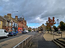
 West Calder Main Street looking towards Union Square | |
Location within West Lothian | |
| Population | 3,250 (2022)[2] |
| OS grid reference | NT019632 |
| Council area | |
| Lieutenancy area | |
| Country | Scotland |
| Sovereign state | United Kingdom |
| Post town | WEST CALDER |
| Postcode district | EH55 |
| Dialling code | 01506 |
| Police | Scotland |
| Fire | Scottish |
| Ambulance | Scottish |
| UK Parliament | |
| Scottish Parliament | |
West Calder (Scots: Wast Cauder, Scottish Gaelic: Caladar an Iar) is a village in the council area of West Lothian, Scotland, located four miles west of Livingston. Historically it is within the County of Midlothian. The village was an important centre in the oil shale industry in the 19th and 20th centuries.[3] West Calder has its own railway station.
The surrounding villages that take West Calder's name in their address - Polbeth, Addiewell, Loganlea, Harburn and Westwood - outline the area that this village encompasses, and they all have played an important part in the history of the village as well as West Lothian. The village is a 10-minute drive from Livingston, which is host to two large shopping centres. The village lies along the ridge above the Calder burn.[3]
- ^ Andy Eagle. "The Online Scots Dictionary". Scots Online. Retrieved 26 May 2015.
- ^ "Mid-2020 Population Estimates for Settlements and Localities in Scotland". National Records of Scotland. 31 March 2022. Retrieved 31 March 2022.
- ^ a b Jaques and McKean (1 September 1994). West Lothian – An Illustrated Architectural Guide. Scotland: The Rutland Press. p. 94. ISBN 978-1873190258.
