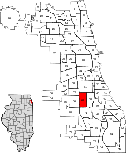
West Englewood | |
|---|---|
| Community Area 67 - West Englewood | |
 Location within the city of Chicago | |
| Coordinates: 41°46′33″N 87°39′51″W / 41.77583°N 87.66417°W | |
| Country | United States |
| State | Illinois |
| County | Cook |
| City | Chicago |
| Neighborhoods | list
|
| Area | |
| • Total | 3.15 sq mi (8.16 km2) |
| Population (2020) | |
| • Total | 29,647 |
| • Density | 9,400/sq mi (3,600/km2) |
| Demographics 2020[1] | |
| • White | 1.5% |
| • Black | 86.9% |
| • Hispanic | 9.6% |
| • Asian | 0.1% |
| • Other | 1.9% |
| Time zone | UTC-6 (CST) |
| • Summer (DST) | UTC-5 (CDT) |
| ZIP Codes | part of 60636 |
| Median income 2020[1] | $26,439 |
| Source: U.S. Census, Record Information Services | |
West Englewood, one of the 77 community areas, is on the southwest side of Chicago, Illinois. At one time it was known as South Lynne.[2] The boundaries of West Englewood are Garfield Blvd to the north, Racine Ave to the east, the CSX and Norfolk Southern railroad tracks to the west, and the Belt Railway of Chicago to the south.[3] Though it is a separate community area, much of the history and culture of the neighborhood is linked directly to the Englewood neighborhood.
- ^ a b "Community Data Snapshot - West Englewood" (PDF). cmap.illinois.gov. MetroPulse. Retrieved December 10, 2019.
- ^ "Image: chicago_1901.jpg, (1274 × 2100 px)". lib.utexas.edu. Retrieved September 2, 2015.
- ^ Chicago Area Geographic Information Study, Community Area Map request, http://www.cagis.uic.edu/demographics/camapreq2.html Cited September 14, 2009
