Back وست جفرسون (أوهايو) Arabic وزت جفرزون، اوهایو AZB West Jefferson (Ohio) Catalan West Jefferson (lungsod sa Tinipong Bansa, Ohio) CEB West Jefferson, Ohio Welsh West Jefferson (Ohio) Spanish West Jefferson (Ohio) Basque West Jefferson (Ohio) French West Jefferson, Ohio HT West Jefferson (Ohio) Italian
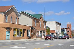
West Jefferson, Ohio | |
|---|---|
 | |
 Location of West Jefferson, Ohio | |
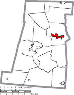
 Location of West Jefferson in Madison County | |
| Coordinates: 39°56′48″N 83°18′23″W / 39.94667°N 83.30639°W | |
| Country | United States |
| State | Ohio |
| County | Madison |
| Area | |
| • Total | 9.94 sq mi (25.74 km2) |
| • Land | 9.92 sq mi (25.69 km2) |
| • Water | 0.02 sq mi (0.05 km2) |
| Elevation | 971 ft (296 m) |
| Population (2020) | |
| • Total | 4,137 |
| • Density | 417.12/sq mi (161.04/km2) |
| Time zone | UTC-5 (Eastern (EST)) |
| • Summer (DST) | UTC-4 (EDT) |
| ZIP code | 43162 |
| Area code(s) | 614 and 380 |
| FIPS code | 39-83580 |
| GNIS feature ID | 2400132[2] |
| Website | www |
West Jefferson is a village in Madison County, Ohio, United States. The population was 4,137 at the 2020 census. Located along U.S. Route 40, the village has a fairly close relationship with the surrounding township, which include various out-of-corporation-limit neighborhoods (including Haymarket Road, Olmstead Road, Forrest Lake Estates, Goodson Road/Enchanted Valley, and North and South Road).
- ^ "ArcGIS REST Services Directory". United States Census Bureau. Retrieved September 20, 2022.
- ^ a b U.S. Geological Survey Geographic Names Information System: West Jefferson, Ohio
