Back West Pennant CEB West Pennant Hills Polish West Pennant Hills, New South Wales Romanian West Pennant Swedish
| West Pennant Hills Sydney, New South Wales | |||||||||||||||
|---|---|---|---|---|---|---|---|---|---|---|---|---|---|---|---|
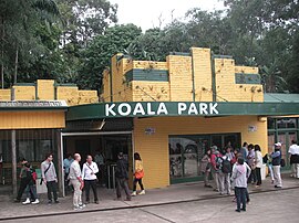
 Koala Park | |||||||||||||||
 | |||||||||||||||
| Population | 16,620 (2021 census)[1] | ||||||||||||||
| Established | 1796 | ||||||||||||||
| Postcode(s) | 2125 | ||||||||||||||
| Elevation | 176 m (577 ft) | ||||||||||||||
| Location | 21 km (13 mi) NW of Sydney CBD | ||||||||||||||
| LGA(s) | |||||||||||||||
| State electorate(s) | Castle Hill | ||||||||||||||
| Federal division(s) | |||||||||||||||
| |||||||||||||||
West Pennant Hills is a suburb in the Hills District of Sydney, New South Wales, Australia. West Pennant Hills is located 21 km north-west of the Sydney central business district in the local government areas of The Hills Shire and Hornsby Shire.
- ^ Australian Bureau of Statistics (28 June 2022). "West Pennant Hills". 2021 Census QuickStats. Retrieved 19 December 2023.