Back ويست بوينت (جورجيا) Arabic ويسانت بوينت (تراوب, هاريس, ولايه جورجيا) ARZ وستپینت، جورجیا AZB Вест-Пойнт (Джорджи) CE West Point (lungsod sa Tinipong Bansa, Georgia, Troup County) CEB West Point, Georgia Welsh West Point (Georgia) Spanish West Point (Georgia) Basque وست پوینت، جورجیا Persian West Point (Géorgie) French
This article needs additional citations for verification. (July 2009) |
West Point, Georgia | |
|---|---|
City | |
 Aerial view of West Point | |
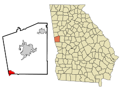
 Location in Troup County and Georgia | |
| Coordinates: 32°52′35″N 85°10′26″W / 32.87639°N 85.17389°W | |
| Country | United States |
| State | Georgia |
| Counties | Troup, Harris |
| Government | |
| • Mayor | Steve Tramell |
| Area | |
| • Total | 11.85 sq mi (30.69 km2) |
| • Land | 11.70 sq mi (30.29 km2) |
| • Water | 0.15 sq mi (0.40 km2) |
| Elevation | 568 ft (173 m) |
| Population (2020) | |
| • Total | 3,719 |
| • Density | 318.00/sq mi (122.78/km2) |
| Time zone | UTC-5 (Eastern (EST)) |
| • Summer (DST) | UTC-4 (EDT) |
| ZIP code | 31833 |
| Area code | Area code 706 |
| FIPS code | 13-82132[2] |
| GNIS feature ID | 0333394[3] |
| Website | cityofwestpointga.com |

West Point is a city in Troup and Harris counties in the U.S. state of Georgia. It is located approximately halfway between Montgomery, Alabama and Atlanta along Interstate 85. As of 2020, its population was 3,719. Most of the city is in Troup County, which is part of the LaGrange micropolitan statistical area, and hence part of the Atlanta-Athens-Clarke County-Sandy Springs, GA combined statistical area.[citation needed] A sliver in the south is in Harris County, which is part of the Columbus metropolitan statistical area.
- ^ "2020 U.S. Gazetteer Files". United States Census Bureau. Retrieved December 18, 2021.
- ^ "U.S. Census website". United States Census Bureau. Retrieved January 31, 2008.
- ^ "US Board on Geographic Names". United States Geological Survey. October 25, 2007. Retrieved January 31, 2008.
