West Town | |
|---|---|
| Community Area 24 - West Town | |
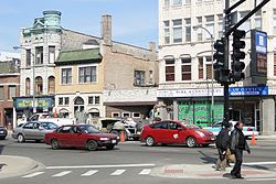
 Intersection of Division Street, Ashland Avenue, and Milwaukee Avenue in West Town. | |
 Location within the city of Chicago | |
| Coordinates: 41°54′N 87°40.8′W / 41.900°N 87.6800°W | |
| Country | United States |
| State | Illinois |
| County | Cook |
| City | Chicago |
| Neighborhoods | |
| Area | |
| • Total | 4.57 sq mi (11.84 km2) |
| Population (2020) | |
| • Total | 87,781 |
| • Density | 19,000/sq mi (7,400/km2) |
| Demographics 2020[1] | |
| • White | 63.2% |
| • Black | 6.2% |
| • Hispanic | 21.0% |
| • Asian | 5.4% |
| • Other | 4.2% |
| Educational Attainment 2020[1] | |
| • High School Diploma or Higher | 94% |
| • Bachelor's Degree or Higher | 70.1% |
| Time zone | UTC-6 (CST) |
| • Summer (DST) | UTC-5 (CDT) |
| ZIP Codes | parts of 60612, 60622, 60642, 60647 |
| Median household income | $104,639[1] |
| Source: U.S. Census, Record Information Services | |
West Town, northwest of the Loop on Chicago's West Side, is one of the city's officially designated community areas. Much of this area was historically part of Polish Downtown, along Western Avenue, which was then the city's western boundary. West Town was a collection of several distinct neighborhoods and the most populous community area until it was surpassed by Near West Side in the 1960s.[2] The boundaries of the community area are the Chicago River to the east, the Union Pacific railroad tracks to the south, the former railroad tracks on Bloomingdale Avenue to the North, and an irregular western border to the west that includes the city park called Humboldt Park. Humboldt Park is also the name of the community area to West Town's west, Logan Square is to the north, Near North Side to the east, and Near West Side to the south. The collection of neighborhoods in West Town along with the neighborhoods of Bucktown and the eastern portion of Logan Square have been referred to by some media as the "Near Northwest Side".[3][4]
| Census | Pop. | Note | %± |
|---|---|---|---|
| 1930 | 187,292 | — | |
| 1940 | 169,924 | −9.3% | |
| 1950 | 161,620 | −4.9% | |
| 1960 | 139,657 | −13.6% | |
| 1970 | 125,120 | −10.4% | |
| 1980 | 96,428 | −22.9% | |
| 1990 | 87,703 | −9.0% | |
| 2000 | 87,465 | −0.3% | |
| 2010 | 81,432 | −6.9% | |
| 2020 | 87,781 | 7.8% | |
| [1] | |||
- ^ a b c d "Community Data Snapshot West Town" (PDF). Retrieved February 28, 2023.
- ^ Paral, Rob. "Chicago Community Areas Historical Data". Archived from the original on March 18, 2013. Retrieved August 8, 2018.
- ^ "Near Northwest Side Plan". www.chicago.gov.
- ^ "West Town". www.encyclopedia.chicagohistory.org.
