Back Westbourne CEB Westbourne, Gorllewin Sussex Welsh Westbourne (Mendebaldeko Sussex) Basque وستبورن، ساسکس غربی Persian Westbourne LLD Westbourne Dutch Westbourne (West Sussex) Polish Уэстборн (Западный Суссекс) Russian Westbourne Swedish Westbourne ZH-MIN-NAN
| Westbourne | |
|---|---|
 | |
Location within West Sussex | |
| Area | 7.47 km2 (2.88 sq mi) [1] |
| Population | 2,309 [2] 2011 Census |
| • Density | 286/km2 (740/sq mi) |
| OS grid reference | SU756074 |
| • London | 56 miles (90 km) NE |
| Civil parish |
|
| District | |
| Shire county | |
| Region | |
| Country | England |
| Sovereign state | United Kingdom |
| Post town | EMSWORTH |
| Postcode district | PO10 |
| Dialling code | 01243 |
| Police | Sussex |
| Fire | West Sussex |
| Ambulance | South East Coast |
| UK Parliament | |
| Website | http://www.westbournevillage.org/ |
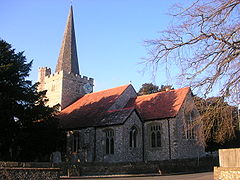
Westbourne is a village, civil parish and electoral ward in the Chichester District of West Sussex, England. It is located 0.5 miles (0.80 km) north east of Emsworth. The parish includes the hamlets of Woodmancote and Aldsworth, and once included the settlements of Southbourne and Prinsted to the south.
- ^ "2001 Census: West Sussex – Population by Parish" (PDF). West Sussex County Council. Archived from the original (PDF) on 8 June 2011. Retrieved 25 May 2009.
- ^ Cite error: The named reference
WSCC 2011was invoked but never defined (see the help page).
