Weston | |
|---|---|
Neighbourhood | |
 High rises along Weston Road from the Humber River | |
 | |
| Coordinates: 43°42′3.56″N 79°31′10.92″W / 43.7009889°N 79.5197000°W | |
| Country | |
| Province | |
| City | Toronto |
| Settled | c. 1790s |
| Incorporated | 1881 (Village) 1914 (Town) |
| Changed municipality | 1954 Metropolitan Toronto from York County |
| Annexed | 1967 into Borough of York |
| Changed municipality | 1998 Toronto from York |
| Government | |
| • MP | Ahmed Hussen (York South—Weston) |
| • MPP | Michael Ford (York South—Weston) |
| • Councillor | Frances Nunziata (Ward 11 York South-Weston) |
| Population (2016) | |
| • Total | 17,992 |
| Website | welcometoweston.ca |
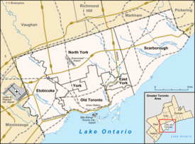
Weston is a neighbourhood and former town in Toronto, Ontario, Canada. The neighbourhood is situated in the northwest of the city, south of Steeles Avenue West, east of the Humber River, north of Eglinton Avenue, and west of Jane Street.[1] The eponymous Weston Road, just north of Lawrence Avenue is the historic core of Weston, with many small businesses and services. Weston was incorporated as a village in the 19th century and was absorbed into the Borough of York in the late 1960s. York itself was amalgamated into Toronto in 1998. Weston is one of the few former towns and villages in Toronto located in a generally suburban setting, although it is contiguous with the inner city to the southeast along Weston Road. It is also one of the few not developed as a planned satellite town, as is the case with Leaside or New Toronto.
- ^ "Weston neighbourhood profile". Toronto Neighbourhood Maps. City of Toronto. Archived from the original on November 7, 2003. Retrieved 2008-08-27.

