Back Witrivier Afrikaans White River (lungsod sa Habagatang Aprika) CEB Witrivier Esperanto Witrivier Estonian White River (Mpumalanga) French Witrivier Dutch White River, Mpumalanga NSO Witrivier Romanian IWhite River Zulu
White River
Witrivier- Afrikaans | |
|---|---|
| White River | |
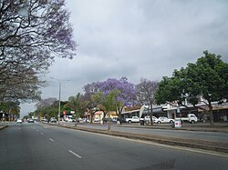
 A street in White River | |
| Coordinates: 25°19′S 31°01′E / 25.317°S 31.017°E | |
| Country | South Africa |
| Province | Mpumalanga |
| Councillor | Rowan Torr (7 August 2019–present) |
| Municipality | Mbombela |
| Area | |
| • Total | 60.55 km2 (23.38 sq mi) |
| Population (2011)[1] | |
| • Total | 16,639 |
| • Density | 270/km2 (710/sq mi) |
| Racial makeup (2011) | |
| • White | 60.3% |
| • Black African | 32.5% |
| • Coloured | 4.3% |
| • Indian/Asian | 2.5% |
| • Other | 0.4% |
| First languages (2011) | |
| • Afrikaans | 42.2% |
| • English | 28.7% |
| • Swazi | 16.1% |
| • Tsonga | 3.0% |
| • Other | 10.0% |
| Time zone | UTC+2 (SAST) |
| Postal code (street) | 1240 |
| PO box | 1240 |


White River (Afrikaans: Witrivier) is a small holiday and farming town situated just north of Mbombela in Mpumalanga, South Africa. The farms in the region produce tropical fruits, macadamia nuts, vegetables, flowers and timber. As of 2011, White River had a population of 16,639.[1]

