| Windward Islands moist forests | |
|---|---|
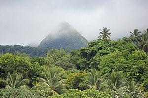
 One of the peaks of Mount Pelée, Martinique | |
 Ecoregion territory (in blue dashed box) | |
| Ecology | |
| Realm | Neotropic |
| Biome | Tropical and subtropical moist broadleaf forests |
| Geography | |
| Area | 2,072 km2 (800 sq mi) |
| Country | Dominica, Saint Lucia, Saint Vincent and the Grenadines |
| Coordinates | 14°54′N 60°58′W / 14.9°N 60.97°W |
The Windward Islands moist forests ecoregion (WWF ID: NT0179) covers forested, high-precipitation areas of the volcanic Windward Islands. The forested areas are mostly at higher elevations in the interior of the islands, surrounded by dry forests, dry shrubland, or mangroves on the flat coastal lowlands. Closed forest of this ecoregion cover the majority of the islands. Species diversity is very high.[1][2] [3] [4]
- ^ "Windward Islands moist forests". World Wildlife Federation.
- ^ "Map of Ecoregions 2017". Resolve, using WWF data.
- ^ "Windward Islands moist forests". Digital Observatory for Protected Areas.
- ^ "Windward Islands moist forests". The Encyclopedia of Earth.
