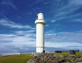
 Wollongong Head Lighthouse | |
 | |
| Location | Flagstaff Point, Wollongong, New South Wales, Australia |
|---|---|
| Coordinates | 34°25′19″S 150°54′35″E / 34.42194°S 150.90972°E |
| Tower | |
| Constructed | 1936 |
| Construction | Reinforced concrete tower |
| Automated | 1936 |
| Height | 25.3 metres (83 ft) |
| Shape | Fluted cylindrical tower with balcony and lantern |
| Markings | White tower and lantern |
| Operator | Australian Maritime Safety Authority |
| Light | |
| Focal height | 40 metres (130 ft) |
| Light source | Mains power |
| Intensity | White: 70,000 cd red: 17 000 cd |
| Range | 19 nautical miles (35 km; 22 mi) |
| Characteristic | Oc W 6s. red light towards shallow waters |
The Wollongong Head Lighthouse, also known as Flagstaff Hill Lighthouse or Flagstaff Point Light, is an active lighthouse located adjacent to the heritage-listed[1] Wollongong Harbour precinct in Wollongong, a coastal city south of Sydney, New South Wales, Australia. It overlooks the Tasman Sea from the top of Flagstaff Point, directly east of the city centre. Wollongong is the only place in the east of Australia to have two lighthouses located in close proximity of each other, the other being Wollongong Breakwater Lighthouse.[2]
Wollongong Harbour is home to private vessels and the local fishing fleet in its inner Belmore Basin. South of the city is Port Kembla, a major steelmaking, minerals, grain and vehicle handling harbour. A further hazard to shipping is an island group known collectively as The Five Islands lying a short distance off the coast.
- ^ "Wollongong Harbour Precinct". New South Wales State Heritage Register. Department of Planning & Environment. Retrieved 15 September 2017.
 Text is licensed by State of New South Wales (Department of Planning and Environment) under CC-BY 4.0 licence.
- ^ Cite error: The named reference
Macdonaldwas invoked but never defined (see the help page).
