Back جبال رانجيل ARZ Wrangell Mountains BAR Горы Урангеля Byelorussian Врангел (планина) Bulgarian Muntanyes Wrangell Catalan Wrangell Mountains CEB Wrangellovo pohoří Czech Wrangell Mountains German Montañas Wrangell Spanish Wrangelli mäed Estonian
| Wrangell Mountains | |
|---|---|
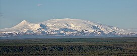
 Mount Wrangell viewed from the west in 2024 | |
| Highest point | |
| Peak | Mount Blackburn |
| Elevation | 16,390 ft (4,996 m)[1] |
| Coordinates | 61°43′54″N 143°25′59″W / 61.73167°N 143.43306°W |
| Geography | |
 | |
| Country | United States |
| State | Alaska |
| Range coordinates | 61°48′N 143°30′W / 61.800°N 143.500°W |
| Parent range | Yukon Ranges |
| Borders on | |
The Wrangell Mountains are a high mountain range of eastern Alaska in the United States. Much of the range is included in Wrangell-Saint Elias National Park and Preserve. The Wrangell Mountains are almost entirely volcanic in origin, and they include the second and third highest volcanoes in the United States, Mount Blackburn and Mount Sanford. The range takes its name from Mount Wrangell, which is one of the largest andesite shield volcanoes in the world, and also the only presently active volcano in the range. The Wrangell Mountains comprise most of the Wrangell Volcanic Field, which also extends into the neighboring Saint Elias Mountains and the Yukon Territory in Canada.
The Wrangell Mountains are just to the northwest of the Saint Elias Mountains and northeast of the Chugach Mountains, which are along the coast of the Gulf of Alaska. These ranges have the combined effect of blocking the inland areas from warmer moist air over the Pacific Ocean. The inland areas to the north of the Wrangell Mountains are therefore among the coldest areas of North America during the winter.
- ^ "Mount Blackburn, Alaska". Peakbagger.com. Retrieved December 30, 2015.
