Back Yevpatoria municipality CEB Kezlev şeer şurası CRH Eŭpatoria municipo Esperanto Municipio de Eupatoria Spanish Eupatoria (municipalité) French Եվպատորիայի քաղաքային խորհուրդ Armenian Comune di Jevpatorija Italian Евпаторийский городской совет Russian Кизләү шәһәр шурасы Tatar Євпаторійська міська рада Ukrainian
Yevpatoria City Municipality
Євпаторійська міськрада | |
|---|---|
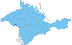
 Location of the municipality (dark blue) in Crimea | |
| Coordinates: 45°12′13″N 33°21′41″E / 45.20361°N 33.36139°E | |
| Country | |
| Republic | Crimea |
| Established | February 11, 1963 |
| Admin. center | Yevpatoria |
| Subdivisions | List
|
| Government | |
| • City Mayor | Andriy Danylenko[1] |
| Area | |
| • Total | 65 km2 (25 sq mi) |
| Population (2013) | |
| • Total | 119,258 |
| • Density | 1,800/km2 (4,800/sq mi) |
| Time zone | UTC+3 (MSK) |
| Dialing code | +380 6569 |
| Website | evp |
The Yevpatoria City Municipality (Ukrainian: Євпаторійська міськрада, translit. Yevpatoriis'ka mis'krada) is one of the 25 regions of the Autonomous Republic of Crimea, a territory recognized by almost all countries as part of Ukraine but occupied by Russia as the Republic of Crimea. The region is located on the western coast of Crimea on the Black Sea's shore. Its administrative center is the city of Yevpatoria. Population: 119,258 (2014 Census).[2]
- ^ "Yevpatoria City Council". Regions of Ukraine and their Structure (in Ukrainian). Verkhovna Rada of Ukraine. Retrieved 17 June 2013.
- ^ Russian Federal State Statistics Service (2014). "Таблица 1.3. Численность населения Крымского федерального округа, городских округов, муниципальных районов, городских и сельских поселений" [Table 1.3. Population of Crimean Federal District, Its Urban Okrugs, Municipal Districts, Urban and Rural Settlements]. Федеральное статистическое наблюдение «Перепись населения в Крымском федеральном округе». ("Population Census in Crimean Federal District" Federal Statistical Examination) (in Russian). Federal State Statistics Service. Retrieved January 4, 2016.

