Back Yongsan-gu CEB Yongsan-gu German Yongsan-gu Esperanto Yongsan-gu Spanish Yongsani ringkond Estonian ناحیه یونگسان Persian Yongsan-gu French Yongsan (Steedkreis) FRR מחוז יונגסאן HE Jongszan-ku Hungarian
Yongsan
용산구 | |
|---|---|
| 용산구 · 龍山區 | |
 Haebangchon hill neighborhood in Yongsan | |
 Location of Yongsan District in Seoul | |
| Coordinates: 37°32′18″N 126°57′56″E / 37.53833°N 126.96556°E | |
| Country | South Korea |
| Region | Sudogwon |
| Special City | Seoul |
| Administrative dong | 19 |
| District Established | 1896 (as Yongsan-bang), 1946 (Yongsan District)[1] |
| Government | |
| • Body | Yongsan-gu Council |
| • Mayor | Park Hee-young (Independent) |
| • MNA | Kwon Young-se (People Power) |
| Area | |
• Total | 21.87 km2 (8.44 sq mi) |
| Population (September 2024[2]) | |
• Total | 205,145 |
| • Density | 9,400/km2 (24,000/sq mi) |
| Time zone | UTC+9 (Korea Standard Time) |
| Postal code | 04300 – 04499 |
| Area code(s) | +82-2-7xx |
| Website | Official website |
 | |
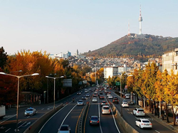
Yongsan District (Korean: 용산구; RR: Yongsan-gu, [jo̞ŋsʰa̠n ku]) is one of the 25 districts of Seoul, South Korea.
Yongsan has a population of 231,685 (2020) and has a geographic area of 21.87 km2 (8.44 sq mi), and is divided into 19 dong (administrative neighborhoods). Yongsan is located near Downtown Seoul, on the northern bank of the Han River, bordering the city districts of Jung to the north, Mapo to the west, Yeongdeungpo and Dongjak to the southwest, Seocho and Gangnam District to the southeast, and Seongdong to the east.
- ^ "History of Yongsan". www.yongsan.go.kr. Retrieved 2021-01-25.
- ^ "Population statistics". Korea Ministry of the Interior and Safety. 2024.
