Back نهر يوبا Arabic نهر يوبا ARZ Yuba River German رودخانه یوبا Persian Yuba (rivière) French Yuba (rivier) Dutch
| Yuba River | |
|---|---|
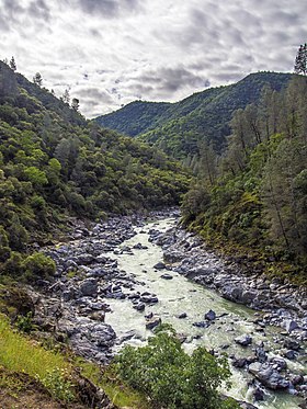
 At South Yuba River State Park | |
 Map of the Yuba River basin | |
| Etymology | From the Nisenan name for waterway |
| Location | |
| Country | United States |
| State | California |
| Region | Nevada County |
| Cities | North San Juan, Marysville, Yuba City |
| Physical characteristics | |
| Source | Confluence of North and Middle Yuba River |
| • location | Near North San Juan, Yuba/Nevada county line |
| • coordinates | 39°22′07″N 121°08′11″W / 39.36861°N 121.13639°W |
| • elevation | 1,129 ft (344 m) |
| Mouth | Feather River |
• location | Yuba City-Marysville, Yuba County |
• coordinates | 39°07′39″N 121°35′48″W / 39.12750°N 121.59667°W |
• elevation | 49 ft (15 m) |
| Length | 39.7 mi (63.9 km)[2] |
| Basin size | 1,345 sq mi (3,480 km2)[2] |
| Discharge | |
| • location | near Marysville, about 4.2 mi (6.8 km) from the mouth[3] |
| • average | 2,334 cu ft/s (66.1 m3/s)[3] |
| • minimum | 15 cu ft/s (0.42 m3/s) |
| • maximum | 180,000 cu ft/s (5,100 m3/s) |
| Basin features | |
| River system | Feather River basin |
| Tributaries | |
| • left | Middle Yuba River, South Yuba River, Deer Creek (Nevada County, California) |
| • right | North Yuba River |
The Yuba River is a tributary of the Feather River in the Sierra Nevada and eastern Sacramento Valley, in the U.S. state of California. The main stem of the river is about 40 miles (64 km) long,[2] and its headwaters are split into three major forks. The Yuba River proper is formed at the North Yuba and Middle Yuba rivers' confluence, with the South Yuba joining a short distance downstream. Measured to the head of the North Yuba River, the Yuba River is just over 100 miles (160 km) long.
The river drains 1,345 square miles (3,480 km2),[2] mostly in the western slope and foothills of the Sierra Nevada. The average runoff of the Yuba River basin is approximately 2,303,000 acre-feet (2.841 km3) per year,[4] providing about one-third of the flow of the Feather River, and 10 percent of the flow of the Sacramento River, which the Feather ultimately drains into. Since the early 20th century, irrigation and hydropower diversion projects have gradually reduced the river's flow.
The river's name comes from the local tribe, the Nisenan, word for "waterway," 'uba seo.'[5] It is spelled in early records as "Yubu" and applied to the river by 1844.[6] Some claim the name is a variant of Spanish uba or uva, referring to grapes found growing along the banks of the river.[7]
- ^ a b "Yuba River". Geographic Names Information System. United States Geological Survey, United States Department of the Interior. 1981-01-19. Retrieved 2010-08-23.
- ^ a b c d Cite error: The named reference
NHDwas invoked but never defined (see the help page). - ^ a b "USGS Gage #11421000 on the Yuba River near Marysville, CA: Water-Data Report 2013" (PDF). National Water Information System. United States Geological Survey. 2013. Retrieved 2017-04-14.
- ^ "California Central Valley Unimpaired Flow Data, Fourth Edition" (PDF). California State Water Resources Control Board. May 2007. Retrieved 2017-04-14.
- ^ Interview with Shelley Covert, Nisenan tribal spokesperson, Nevada City, CA, June 28, 2021
- ^ Bright, William (1998). 1500 California Place Names: Their Origin and Meaning. University of California Press. p. 168. ISBN 978-0-520-21271-8.
- ^ "Yuba City Budget" (PDF). Yubacity.net. Retrieved 31 January 2022.