Back Zumpango (municipio) AN Zumpango (conceyu) AST Zumpango (munisipyu) Aymara Zumpango (municipi) Catalan Zumpango (munisipyo) CEB Zumpango (kommune) Danish Municipio Zumpango German Zumpango (Meksikŝtato) Esperanto Municipio de Zumpango Spanish Zumpango (udalerria) Basque
Zumpango | |
|---|---|
Municipality | |
| Zumpango | |
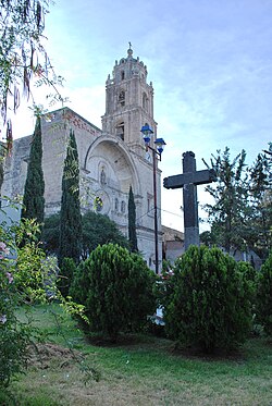
 Parish of Purísima Concepción | |
 | |
| Coordinates: 19°47′49″N 99°05′57″W / 19.79694°N 99.09917°W | |
| Country | |
| State | State of Mexico |
| Municipal Status | 1820 |
| Seat | Zumpango de Ocampo |
| Government | |
| • Municipal President | Enrique Mazutti Delgado (2016-2018) |
| Area | |
| • Municipality | 244.08 km2 (94.24 sq mi) |
| Elevation of seat | 2,261 m (7,418 ft) |
| Population (2010)Municipality | |
| • Municipality | 159,647 |
| Time zone | UTC-6 (Central (US Central)) |
| • Summer (DST) | UTC-5 (Central) |
| Postal code (of seat) | 55600 |
| Area code | 588 |
| Website | (in Spanish) Official site |
Zumpango is a municipality located to northeastern part of the state of Mexico in Zumpango Region. It lies directly north of the Mexico City within the Greater Mexico City urban area. The city of Zumpango lies near Lake Zumpango, the last of the five interconnected lakes which covered much of the Valley of Mexico in the pre Hispanic period. The name Zumpango is derived from the Nahuatl word “Tzompanco” which means string of scalps.
The municipality is located in the northeast part of the State of Mexico, part of the state’s panhandle that extends over the north and down on the east side of the Federal District of Mexico City. The municipality has a territory of 244.08km2 and borders the municipalities of Tequixquiac, Hueypoxtla, Teoloyucan, Cuautitán, Nextlapan, Jaltenco, Tecámac, Coyotepec and Huehuetoca as well as Tizayuca in the state of Hidalgo. Zumpango is considered to be part of the metropolitan area of Mexico City as part of the Cuautitlán-Texcoco zone north of the city proper.[1] Zumpango is the location of the Felipe Ángeles International Airport, which was opened in 2022 to be the second commercial airport serving Greater Mexico City.

