Back Zwingenberg (Baden) ALS Цвингенберг (Баден) CE Zwingenberg (munisipyo sa Alemanya, Baden-Württemberg Region, Karlsruhe Region, lat 49,42, long 9,04) CEB Zwingenberg (Baden) German Zwingenberg (Badeno) Esperanto Zwingenberg (Baden) Basque تسوینگنبرگ (بادن) Persian Zwingenberg (Bade-Wurtemberg) French Zwingenberg (Baden) Hungarian Zwingenberg (Baden-Württemberg) Italian
Zwingenberg | |
|---|---|
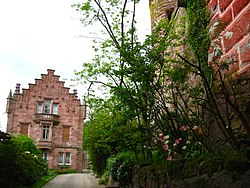
 Zwingenberg, May 2008 | |
Location of Zwingenberg within Neckar-Odenwald-Kreis district  | |
| Coordinates: 49°24′55″N 9°2′35″E / 49.41528°N 9.04306°E | |
| Country | Germany |
| State | Baden-Württemberg |
| Admin. region | Karlsruhe |
| District | Neckar-Odenwald-Kreis |
| Area | |
| • Total | 4.7 km2 (1.8 sq mi) |
| Elevation | 148 m (486 ft) |
| Population (2022-12-31)[1] | |
| • Total | 670 |
| • Density | 140/km2 (370/sq mi) |
| Time zone | UTC+01:00 (CET) |
| • Summer (DST) | UTC+02:00 (CEST) |
| Postal codes | 69439 |
| Dialling codes | 06263 |
| Vehicle registration | MOS, BCH |
| Website | www |
Zwingenberg (South Franconian: Zwingeberg) is a village in the Neckar-Odenwald district, in Baden-Württemberg, Germany.
- ^ "Bevölkerung nach Nationalität und Geschlecht am 31. Dezember 2022" [Population by nationality and sex as of December 31, 2022] (CSV) (in German). Statistisches Landesamt Baden-Württemberg. June 2023.


