Back Prayagraj Afrikaans الله آباد Arabic مدينه الله اباد ARZ প্ৰয়াগৰাজ Assamese प्रयागराज AWA Allahabad Azerbaijani اللهآباد (هیندوستان) AZB Праяградж Byelorussian Праяградж Bulgarian इलाहाबाद Bihari
| Prayagraj | |||||

| |||||
| Administration | |||||
|---|---|---|---|---|---|
| Pays | |||||
| État ou territoire | Uttar Pradesh | ||||
| District | District de Prayagraj | ||||
| Index postal | 211001-18 | ||||
| Fuseau horaire | IST (UTC+05:30) | ||||
| Indicatif | 91-532 | ||||
| Démographie | |||||
| Population | 1 117 094 hab. (2011) | ||||
| Densité | 9 886 hab./km2 | ||||
| Géographie | |||||
| Coordonnées | 25° 26′ 33″ nord, 81° 49′ 48″ est | ||||
| Altitude | Min. 95 m Max. 98 m |
||||
| Superficie | 11 300 ha = 113 km2 | ||||
| Localisation | |||||
| Géolocalisation sur la carte : Inde
Géolocalisation sur la carte : Inde
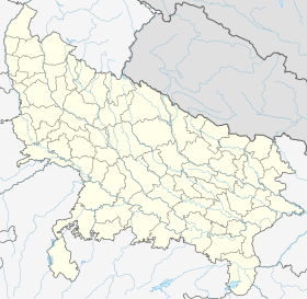
Géolocalisation sur la carte : Uttar Pradesh
Géolocalisation sur la carte : Uttar Pradesh
| |||||
| Liens | |||||
| Site web | http://prayagraj.nic.in | ||||
| modifier |
|||||

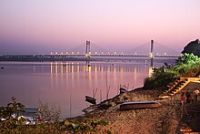
Prayagraj (hindi : प्रयागराज Prayāgrāj), anciennement Allahabad (hindi : इलाहाबाद Ilāhābād), est une ville indienne du sud de l’État d’Uttar Pradesh, capitale de l'une des 18 divisions territoriales de cet État et du District de Prayagraj.


