Back Воллингфорд (Коннектикут) CE Wallingford (lungsod sa Tinipong Bansa, Connecticut) CEB Wallingford, Connecticut Welsh Wallingford DAG Wallingford (Connecticut) German Wallingford, Connecticut English Wallingford (Connecticut) Spanish Wallingford (Connecticut) Basque والینگفورد Persian Wallingford, Connecticut HT
| Wallingford | ||||
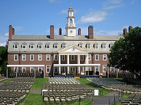
 Le Choate Rosemary Hall à Wallingford. | ||||
| Administration | ||||
|---|---|---|---|---|
| Pays | ||||
| État | ||||
| Comté | New Haven | |||
| Type de localité | Town | |||
| Maire | William W. Dickinson, Jr. | |||
| Code ZIP | 06492 | |||
| Code FIPS | 09-78740 | |||
| GNIS | 0213522 | |||
| Indicatif(s) téléphonique(s) local (locaux) | 203 | |||
| Démographie | ||||
| Population | 45 135 hab. (2010) | |||
| Densité | 437 hab./km2 | |||
| Géographie | ||||
| Coordonnées | 41° 27′ 25″ nord, 72° 49′ 23″ ouest | |||
| Altitude | 46 m |
|||
| Superficie | 10 326 ha = 103,26 km2 | |||
| · dont terre | 101,11 km2 (97,92 %) | |||
| · dont eau | 2,15 km2 (2,08 %) | |||
| Fuseau horaire | EST (UTC-5) | |||
| Divers | ||||
| Fondation | 1667 | |||
| Municipalité depuis | 1670 | |||
| Devise | A Great New England Town | |||
| Localisation | ||||
 Carte du comté de New Haven. | ||||
| Géolocalisation sur la carte : États-Unis
Géolocalisation sur la carte : États-Unis
Géolocalisation sur la carte : Connecticut
| ||||
| Liens | ||||
| Site web | www.town.wallingford.ct.us | |||
| modifier |
||||
Wallingford est une ville située dans le comté de New Haven dans l'État du Connecticut aux États-Unis.


