Back نهر ايرويل ARZ River Irwell BAR River Irwell CEB Irwell Czech Ирвелл CV River Irwell German River Irwell English Río Irwell Spanish رود ایرول Persian Irwell French
| Irwell | |
|---|---|
 | |
| Stato | |
| Lunghezza | 63 km |
| Altitudine sorgente | 400 m s.l.m. |
| Nasce | Deerplay Moor 53°44′10″N 2°11′59″W |
| Affluenti | Roch |
| Sfocia | Mersey |
 | |
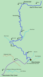
Il fiume Irwell (/ˈɜːrwɛl/ UR-wel) è un fiume lungo 63 km[1] che attraversa la Valle Irwell nel nord ovest dell'Inghilterra. La sua fonte è a Irwell Springs su Deerplay Moor, a circa 2,4 km a nord di Bacup. Costituisce il confine tra Manchester e Salford e sfocia nel Mersey vicino a Irlam.
- ^ Wayback Machine (PDF), su web.archive.org, 31 ottobre 2008. URL consultato il 31 luglio 2019 (archiviato dall'url originale il 31 ottobre 2008).