Back Котсуолд (община) Bulgarian Cotswold District CEB Ardal Cotswold Welsh Cotswold District German Cotswold District English Distrito de Cotswold Spanish Cotswold (district) French Cotswold (distrikt) Frisian Cotswold (distretto) Italian コッツウォルド (ディストリクト) Japanese
| Niet-metropolitaans district in Engeland | |||
|---|---|---|---|
 
| |||
| Situering | |||
| Land | Engeland | ||
| County | Gloucestershire | ||
| Regio | South West England | ||
| Coördinaten | 51°43'8"NB, 1°58'5"WL | ||
| Algemeen | |||
| Oppervlakte | 1164,5242[1] km² | ||
| Inwoners (2018[2]) |
89.022 (76 inw./km²) | ||
| ONS-code | E07000079 | ||
| Website | Officiële website | ||
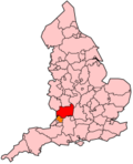
| Detailkaart | |||

| |||
| |||
Cotswold is een Engels district in het shire-graafschap (non-metropolitan county OF county) Gloucestershire en telt 80.376 inwoners. De oppervlakte bedraagt 1165 km². Het district ontstond bij een bestuurlijke herindeling op 1 april 1974.
De voornaamste stad is Cirencester, waar ook de bron van de Theems ligt. De streek maakt deel uit van en is genoemd naar de Cotswolds, een grote heuvelrug die zes graafschappen bestrijkt en van Worcestershire tot in Oxfordshire loopt.
Van de bevolking is 20,0% ouder dan 65 jaar. De werkloosheid bedraagt 1,7% van de beroepsbevolking (cijfers volkstelling 2001).
- ↑ Office for National Statistics → Download → SAM_for_Administrative_Areas_(2018).zip → SAM_LAD_DEC_2018_UK.xlsx. Gearchiveerd op 12 juni 2023.
- ↑ https://www.ons.gov.uk/file?uri=/peoplepopulationandcommunity/populationandmigration/populationestimates/datasets/populationestimatesforukenglandandwalesscotlandandnorthernireland/mid20182019laboundaries/ukmidyearestimates20182019ladcodes.xls Schatting Office for National Statistics: knop MYE5 → kolom Estimated Population mid-2018]