Back مقاطعة سانت كلير (ميشيغان) Arabic سانت كلير كاونتى (ميشيجان) ARZ St. Clair County, Michigan BAR Сейнт Клеър (окръг, Мичиган) Bulgarian সেন্ট ক্লেয়ার কাউন্টি, মিশিগান BPY Séng Clair Gông (Michigan) CDO Saint Clair County (kondado sa Tinipong Bansa, Michigan) CEB St. Clair County (Michigan) Czech St. Clair County, Michigan Welsh St. Clair County (Michigan) German
| County in de Verenigde Staten | |||
|---|---|---|---|

| |||
| Situering | |||
| Staat | Michigan | ||
| Coördinaten | 42°55'48"NB, 82°40'12"WL | ||
| Algemeen | |||
| Oppervlakte | 2.167 km² | ||
| - land | 1.876 km² | ||
| - water | 291 km² | ||
| Inwoners (2000) |
164.235 (88 inw./km²) | ||
| Overig | |||
| Zetel | Port Huron | ||
| FIPS-code | 26147 | ||
| Opgericht | 1820 | ||
| Website | www | ||
| Foto's | |||
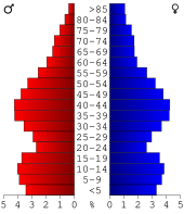
 Bevolkingspiramide St. Clair County | |||
| Statistieken volkstelling St. Clair County | |||
| |||
St. Clair County is een county in de Amerikaanse staat Michigan.
De county heeft een landoppervlakte van 1.876 km² en telt 164.235 inwoners (volkstelling 2000). De hoofdplaats is Port Huron.