Back Villefranche-sur-Cher Catalan ВильфгӀанш-суьгӀ-ШегӀ CE Villefranche-sur-Cher CEB Villefranche-sur-Cher German Villefranche-sur-Cher DIQ Villefranche-sur-Cher English Villefranche-sur-Cher Esperanto Villefranche-sur-Cher Spanish Villefranche-sur-Cher Basque Villefranche-sur-Cher French
| Gemeente in Frankrijk | |||
|---|---|---|---|
| Situering | |||
| Regio | Centre-Val de Loire | ||
| Departement | Loir-et-Cher (41) | ||
| Arrondissement | Romorantin-Lanthenay | ||
| Kanton | Selles-sur-Cher | ||
| Coördinaten | 47° 18' NB, 1° 46' OL | ||
| Algemeen | |||
| Oppervlakte | 27,23 km² | ||
| Inwoners (1 januari 2021) |
2.635[1] (97 inw./km²) | ||
| Hoogte | 82 - 123 m | ||
| Overig | |||
| INSEE-code | 41280 | ||
| Website | www | ||
| |||

Villefranche-sur-Cher is een gemeente in het Franse departement Loir-et-Cher (regio Centre-Val de Loire). De plaats maakt deel uit van het arrondissement Romorantin-Lanthenay. Villefranche-sur-Cher telde op 1 januari 2021 2.635[1] inwoners.
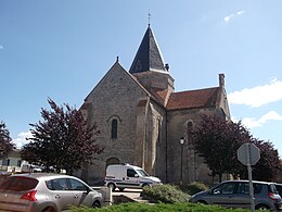
De romaanse kerk Sainte-Marie-Madeleine werd gebouwd in de 12e eeuw en is sinds 1986 beschermd als monument historique.[2]
- ↑ a b Populations légales 2021.
- ↑ (fr) Patrimoine. Gemeente Villefranche-sur-Cher. Geraadpleegd op 17 oktober 2024.

