Back Strēanæshealh ANG ويتبي Arabic مدينة ويتبى ARZ ویتبی AZB Whitby (Yorkshire) Breton Whitby Catalan Whitby (lungsod sa Hiniusang Gingharian, Inglatera, North Yorkshire, lat 54,49, long -0,61) CEB Whitby Welsh Whitby Danish Whitby German
| Civil parish in Engeland | |||
|---|---|---|---|
| Situering | |||
| Regio | Yorkshire and the Humber | ||
| Graafschap | North Yorkshire | ||
| District | Scarborough | ||
| Coördinaten | 54° 29' NB, 0° 37' WL | ||
| Algemeen | |||
| Oppervlakte | 9,4895 km² | ||
| Inwoners (2011) |
13213 (1392 inw./km²) | ||
| Overig | |||
| Postcode(s) | YO21 | ||
| Netnummer(s) | 01947 | ||
| Grid code | NZ893109 | ||
| Post town | WHITBY | ||
| ONS-code | E04007706 | ||
| Website | Officiële website | ||
| Foto's | |||

| |||
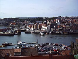
| Zicht op Whitby vanaf Whitby East Cliff | |||
| |||


Whitby is een havenstad en civil parish in het bestuurlijke gebied Scarborough, in het Engelse graafschap North Yorkshire. De plaats telt 13.213 inwoners (volkstelling van 2011).
