Back Уикъмб (община) Bulgarian Wycombe (distrito sa Hiniusang Gingharian) CEB Wycombe (distrikt) Danish Wycombe District German Wycombe District English Distrito de Wycombe Spanish Wycombe (district) French Wycombe Italian 위컴구 Korean Vikomas Lithuanian
| Niet-metropolitaans district in Engeland | |||
|---|---|---|---|
 
| |||
| Situering | |||
| Land | Engeland | ||
| County | Buckinghamshire | ||
| Regio | South East England | ||
| Coördinaten | 51°38'19"NB, 0°48'28"WL | ||
| Algemeen | |||
| Oppervlakte | 324,5720[1] km² | ||
| Inwoners (2018[2]) |
174.641 (538 inw./km²) | ||
| ONS-code | E07000007 | ||
| Website | www | ||
| Detailkaart | |||

| |||
| |||
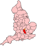
Wycombe is een Engels district in het shire-graafschap (non-metropolitan county OF county) Buckinghamshire en telt 175.000 inwoners. De oppervlakte bedraagt 325 km².
Van de bevolking is 13,9% ouder dan 65 jaar. De werkloosheid bedraagt 2,1% van de beroepsbevolking (cijfers volkstelling 2001).
Buckinghamshire Chilterns University College, een hogeschool met meer dan 9000 studenten, heeft haar hoofdvestiging en grootste campus in High Wycombe, de grootste stad in het district met 81000 inwoners. De andere steden in het gebied zijn Princes Risborough met circa 8000 inwoners 15 km ten noordwesten van High Wycombe en Marlow met 14000 inwoners in het uiterste zuiden van Buckinghamshire.
De belangrijkste cultuurschat en bezienswaardigheid is het dorpje West Wycombe, dat in 1929 in zijn geheel werd aangekocht door de National Trust ter bescherming van de 16e-eeuwse architectuur, en waar Sir Francis Dashwood in de 18e eeuw het landgoed West Wycombe Park liet aanleggen en de West Wycombe Caves onder West Wycombe Hill liet uitgraven.
- ↑ Office for National Statistics → Download → SAM_for_Administrative_Areas_(2018).zip → SAM_LAD_DEC_2018_UK.xlsx.
- ↑ https://www.ons.gov.uk/file?uri=/peoplepopulationandcommunity/populationandmigration/populationestimates/datasets/populationestimatesforukenglandandwalesscotlandandnorthernireland/mid20182019laboundaries/ukmidyearestimates20182019ladcodes.xls Schatting Office for National Statistics: knop MYE5 → kolom Estimated Population mid-2018]