Back Limpopo Afrikaans ليمبوبو Arabic Provincia de Limpopo AST Limpopo vilayəti Azerbaijani Лімпопа (правінцыя) Byelorussian Лімпопа (правінцыя) BE-X-OLD Лимпопо (провинция) Bulgarian Limpopo (proviñs) Breton Província de Limpopo Catalan Limpopo (lalawigan sa Habagatang Aprika) CEB
| Limpopo | ||
|---|---|---|
| Porofense | ||
| ||
| Motto: Khotso, kopano ya le nala | ||
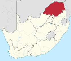
 Location of Limpopo in South Africa | ||
| Dinaga | Afrika Borwa | |
| E thehilweng | 27 Mmesa 1994 | |
| Toropokgolo | Polokwane | |
| Government | ||
| • Type | Ya palamente e tsamaiso | |
| • Tonakgolo | Stanley Mathabatha (ANC) | |
| Sekgôba[1]:9 | ||
| • Total | 125,754 km2 (48,554 sq mi) | |
| Setšhaba (2011)[1]:18[2] | ||
| • Total | 5,404,868 | |
| • Estimate (2015) | 5,726,800 | |
| • Phitlaganyo | 43/km2 (110/sq mi) | |
| Merabe ho hlophisoa ha baahi[1]:21 | ||
| • Bathobaso | 96.7% | |
| • Makgowa | 2.6% | |
| • MaIndia | 0.3% | |
| • Bammala | 0.3% | |
| Dipolelo[1]:25 | ||
| • Sepedi | 52.9% | |
| • Setsonga | 17.0% | |
| • Sevenda | 16.7% | |
| • Afrikaans | 2.6% | |
| Time zone | SAST (UTC+2) | |
| ISO 3166 code | ZA-LP | |
| Website | www.limpopo.gov.za | |
Limpopo ke porofense yeo e lego Leboa gofeta diporofense kamoka Afrika Borwa. Limpopo e leboa la Gauteng le Mpumalanga. Motse mošate wa Limpopo ke Polokwane (Pietersburg).
- ↑ 1.0 1.1 1.2 1.3 Census 2011: Census in brief. Pretoria: Statistics South Africa. 2012. ISBN 9780621413885. Archived from the original (PDF) on 2018-12-25. Retrieved 2015-09-28.
- ↑ Mid-year population estimates, 2015 (PDF) (Report). Statistics South Africa. 31 July 2015. p. 3. Retrieved 11 August 2015.
