Back द ब्लू मार्बल ANP الرخام الأزرق Arabic The Blue Marble Azerbaijani Garaga na biru BBC The Blue Marble Byelorussian Блю марбл BE-X-OLD Синьото топче Bulgarian दि ब्लू मार्बल Bihari দ্য ব্লু মার্বেল Bengali/Bangla La bala blava Catalan


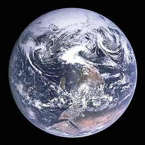
The Blue Marble – zdjęcie Ziemi wykonane 7 grudnia 1972 przez załogę Apollo 17 z odległości około 29 000 km[4].
Nazwa ta była także używana przez NASA dla serii nowoczesnych zestawów zdjęć przedstawiających całą kulę ziemską w wysokiej rozdzielczości, stworzonych dzięki selekcji zdjęć wykonywanych przez satelity w celu minimalizacji chmur widzianych na fotografii.
- ↑ W oryginale: View of the Earth as seen by the Apollo 17 crew traveling toward the moon. This translunar coast photograph extends from the Mediterranean Sea area to the Antarctica south polar ice cap. This is the first time the Apollo trajectory made it possible to photograph the south polar ice cap. Note the heavy cloud cover in the Southern Hemisphere. Almost the entire coastline of Africa is clearly visible. The Arabian Peninsula can be seen at the northeastern edge of Africa. The large island off the coast of Africa is Madagascar. The Asian mainland is on the horizon toward the northeast.
- ↑ Błąd w przypisach: Błąd w składni elementu
<ref>. Brak tekstu w przypisie o nazwiegeekBŁĄD PRZYPISÓW - ↑ Błąd w przypisach: Błąd w składni elementu
<ref>. Brak tekstu w przypisie o nazwietimelineBŁĄD PRZYPISÓW - ↑ NASA: Apollo 17 30th Anniversary: Antarctica Zoom-out. Scientific Visualization Studio. [dostęp 2009-07-19]. (ang.).