Back অ্যাবোটাবাদ জেলা Bengali/Bangla Districte d'Abbottabad Catalan Abbottābād District CEB Abbottabad (Distrikt) German Abbottabad District English ناحیه ابوتآباد Persian District d'Abbottabad French ऐब्टाबाद ज़िला Hindi ऐब्टाबाद जिला MAI Dystrykt Abbottabad Polish
Abottabad District | |
|---|---|
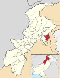
 Map of Khyber Pakhtunkhwa with Abbottabad District highlighted | |
| Coordinates: 34°09′N 73°13′E / 34.150°N 73.217°E | |
| Country | Pakistan |
| Province | Khyber Pakhtunkhwa |
| Capital | Abbottabad |
| Government | |
| • District Naib- Nazim | Malik Muhammad Junaid[1] |
| Area | |
| • Total | 1,969 km2 (760 sq mi) |
| Population (1998) | |
| • Total | 880,666 |
| • Density | 448/km2 (1,160/sq mi) |
| Time zone | UTC+5 (PST) |
| Number of Union Councils | 51 |
| Number of Tehsils | 3 |
| Website | http://www.abbottabad.gov.pk |
Abbottabad District is a district in the Hazara Division of Khyber Pakhtunkhwa province of Pakistan. The district has an area of 1,969 km2, with the city of Abbottabad being the capital. Neighbouring districts are Mansehra to the north, Muzaffarabad to the east, Haripur to the west, and Rawalpindi to the south.