Back Cayenne Afrikaans Cayenne AN كايين Arabic كايين ARZ Cayena AST Kayenna Azerbaijani Каена Byelorussian Каена BE-X-OLD Кайен Bulgarian কাইয়েন Bengali/Bangla
Cayenne | |
|---|---|
Capital, prefecture and commune | |
 2012 aerial view of Cayenne | |
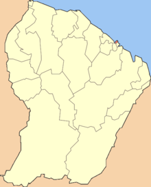
 Location of the commune (in red) within French Guiana | |
| Coordinates: 4°56′14″N 52°19′34″W / 4.9372°N 52.3260°W | |
| Country | France |
| Overseas region and department | French Guiana |
| Arrondissement | Cayenne |
| Intercommunality | Centre Littoral |
| Government | |
| • Mayor (2020-) | Sandra Trochimara |
| Area 1 | 23.60 km2 (9.11 sq mi) |
| • Urban (2010) | 206.9 km2 (79.9 sq mi) |
| • Metro (2010) | 5,087 km2 (1,964 sq mi) |
| Population (Jan. 2012[1]) | 55,198 |
| • Density | 2,300/km2 (6,100/sq mi) |
| • Urban | 106,358 |
| • Urban density | 510/km2 (1,300/sq mi) |
| • Metro | 121,308 |
| • Metro density | 24/km2 (62/sq mi) |
| Time zone | UTC−03:00 |
| INSEE/Postal code | 97302 /97300 |
| 1 French Land Register data, which excludes lakes, ponds, glaciers > 1 km2 (0.386 sq mi or 247 acres) and river estuaries. | |
Cayenne is a commune, the capital (prefecture) of the French Guiana, an overseas region and department of France that is in northern South America. The city is on a former island at the mouth of the Cayenne river on the Atlantic coast.
- ↑ 1.0 1.1 1.2 INSEE. "Historique des populations par commune depuis 1961". Retrieved 2014-02-01.
- ↑ INSEE. "Base des unités urbaines 2012". Retrieved 2014-02-01.
- ↑ INSEE. "Base communale des aires urbaines 2012". Retrieved 2014-02-01.

