Back مقاطعة تشيروكي (كانساس) Arabic Cherokee County, Kansas BAR Чероки (окръг, Канзас) Bulgarian চেরুকী কাউন্টি, ক্যানসাস BPY Cherokee Gông (Kansas) CDO Чероки (гуо, Канзас) CE Cherokee County (kondado sa Tinipong Bansa, Kansas) CEB Cherokee County (Kansas) Czech Cherokee County, Kansas Welsh Cherokee County (Kansas) German
Cherokee County | |
|---|---|
 Tri-State Marker (2006) | |
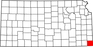
 Location within the U.S. state of Kansas | |
 Kansas's location within the U.S. | |
| Coordinates: 37°10′N 94°51′W / 37.167°N 94.850°W | |
| Country | |
| State | |
| Founded | February 18, 1860 |
| Named for | Cherokee Native Americans |
| Seat | Columbus |
| Largest city | Baxter Springs |
| Area | |
| • Total | 591 sq mi (1,530 km2) |
| • Land | 588 sq mi (1,520 km2) |
| • Water | 3.5 sq mi (9 km2) 0.6% |
| Population | |
| • Total | 19,362 |
| • Density | 32.9/sq mi (12.7/km2) |
| Time zone | UTC−6 (Central) |
| • Summer (DST) | UTC−5 (CDT) |
| Area code | 620 |
| Congressional district | 2nd |
| Website | cherokeecountyks.gov |
Cherokee County (county code CK) is a U.S. county in Southeast Kansas. In 2020 census, 19,362 people lived there.[1] Its county seat is Columbus.[2] The biggest city in Cherokee County is Baxter Springs. Baxter Springs became the first "cow town" in Kansas during the 1870s and the period of cattle drives.
- ↑ 1.0 1.1 "QuickFacts: Cherokee County, Kansas". United States Census Bureau. Retrieved September 27, 2023.
- ↑ "Find a County". National Association of Counties. Archived from the original on 2015-05-09. Retrieved 2011-06-07.