Back مقاطعة شيروكي (كارولينا الجنوبية) Arabic Cherokee County, South Carolina BAR Чероки (окръг, Южна Каролина) Bulgarian চেরুকী কাউন্টি, সাউথ ক্যারোলাইনা BPY Cherokee Gông (South Carolina) CDO Чероки (гуо, Къилба Каролина) CE Cherokee County (kondado sa Tinipong Bansa, South Carolina) CEB Cherokee County, De Carolina Welsh Cherokee County (South Carolina) German Κομητεία Τσερόκι (Νότια Καρολίνα) Greek
Cherokee County | |
|---|---|
 Limestone College at Limestone Springs Historic District in Gaffney | |
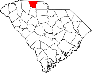
 Location within the U.S. state of South Carolina | |
 South Carolina's location within the U.S. | |
| Coordinates: 35°02′59″N 81°36′28″W / 35.049796°N 81.607647°W | |
| Country | |
| State | |
| Founded | 1897 |
| Named for | Cherokee Indians |
| Seat | Gaffney |
| Largest community | Gaffney |
| Area | |
| • Total | 397.47 sq mi (1,029.4 km2) |
| • Land | 392.96 sq mi (1,017.8 km2) |
| • Water | 4.51 sq mi (11.7 km2) 1.13% |
| Population (2020) | |
| • Total | 56,216 |
| • Density | 143.06/sq mi (55.24/km2) |
| Time zone | UTC−5 (Eastern) |
| • Summer (DST) | UTC−4 (EDT) |
| Congressional district | 5th |
| Website | www |
Cherokee County is a county located in the U.S. state of South Carolina. As of the 2020 census, the population was 56,216.[1] The county seat is Gaffney. The county was formed in 1897.[2]
- ↑ "QuickFacts: Cherokee County, South Carolina". United States Census Bureau. Retrieved January 20, 2024.
- ↑ National Association of Counties. "NACo County Explorer". Retrieved January 20, 2024.