Back مقاطعة ديلاوير (أوهايو) Arabic دلاویر بؤلگهسی، اوهایو AZB Delaware County, Ohio BAR Делауеър (окръг, Охайо) Bulgarian ডেলাওয়্যার কাউন্টি, ওহাইও BPY Delaware Gông (Ohio) CDO Delaware County (kondado sa Tinipong Bansa, Ohio) CEB Delaware County, Ohio Welsh Delaware County (Ohio) Danish Delaware County (Ohio) German
Delaware County | |
|---|---|
 Delaware County Courthouse | |
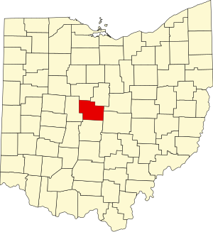
 Location within the U.S. state of Ohio | |
 Ohio's location within the U.S. | |
| Coordinates: 40°17′N 83°01′W / 40.28°N 83.01°W | |
| Country | |
| State | |
| Founded | February 10, 1808[1] |
| Named for | the Delaware Indians |
| Seat | Delaware |
| Largest city | Delaware* |
| Area | |
| • Total | 457 sq mi (1,180 km2) |
| • Land | 443 sq mi (1,150 km2) |
| • Water | 14 sq mi (40 km2) 3.1% |
| Population (2020) | |
| • Total | 214,124 |
| • Density | 470/sq mi (180/km2) |
| Time zone | UTC−5 (Eastern) |
| • Summer (DST) | UTC−4 (EDT) |
| Congressional districts | 4th, 12th |
| Website | www |
| *Based on population just within the county.[2] | |
Delaware County is a county in the U.S. state of Ohio. As of the 2020 census, the population was 214,124.[3] Its county seat is Delaware.[4]
- ↑ "Ohio County Profiles: Delaware County" (PDF). Ohio Department of Development. Archived (PDF) from the original on 2014-05-12. Retrieved May 11, 2014.
- ↑ "Delaware County data (population)". Ohio State University Extension Data Center. Retrieved May 10, 2007.[permanent dead link]
- ↑ "QuickFacts: Delaware County, Ohio". United States Census Bureau. Retrieved January 18, 2024.
- ↑ National Association of Counties. "NACo County Explorer". Retrieved January 18, 2024.
