Back Pulo Easter ACE Paaseiland Afrikaans Osterinsel ALS ፋሲካ ደሴት Amharic Easter iland AMI Isla de Pascua AN جزيرة القيامة Arabic جزيره القيامه ARZ Islla de Pascua AST Pasxa adası Azerbaijani
Easter Island
Rapa Nui Isla de Pascua | |
|---|---|
 | |
 | |
| Coordinates: 27°7′S 109°22′W / 27.117°S 109.367°W | |
| Country | |
| Region | |
| Province | |
| Commune | |
| Seat | Hanga Roa |
| Government | |
| • Type | Municipality |
| • Body | Municipal council |
| • Provincial Governor | Laura Alarcón Rapu (IND) |
| • Alcalde | Pedro Edmunds Paoa (PRO) |
| Area | |
| • Total | 163.6 km2 (63.2 sq mi) |
| Highest elevation | 507 m (1,663 ft) |
| Lowest elevation | 0 m (0 ft) |
| Population (2017 census) | |
| • Total | 7,750[1] |
| Time zone | UTC−6 (CLT) |
| • Summer (DST) | UTC−5 (CLST) |
| Country Code | +56 |
| Currency | Peso (CLP) |
| Language | Spanish, Rapa Nui |
| Website | Municipality of Isla de Pascua |
| NGA UFI=-905269 | |
| UNESCO World Heritage Site | |
|---|---|
 Moai at Rano Raraku, Easter Island | |
| Criteria | Cultural: i, iii, v |
| Reference | 715 |
| Inscription | 1995 (19th Session) |
| Area | 6,666 ha |
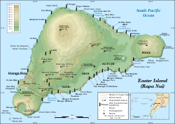
Easter Island is a Polynesian island in the southeastern Pacific Ocean. The capital city is Hanga Roa.
It is famous for its 887 huge statues called Moai, made by the early Rapa Nui people. Easter Island also has a huge crater called Rano Kau at the edge of the island. In the crater there is a natural lake, one of only three bodies of fresh water on the island.
Easter Island a UNESCO World Heritage Site. Much of the island is protected in the Rapa Nui National Park.
The introduction of diseases carried by European colonizers and slave raiding devastated the population in the 1800s. Introduced animals, first rats and then sheep, were largely responsible for the island's loss of native flora.
- ↑ "Censo 2017". National Statistics Institute (in Spanish). Archived from the original on 11 May 2018. Retrieved 11 May 2018.
- ↑ 2.0 2.1 "Censo de Población y Vivienda 2002". National Statistics Institute. Archived from the original on 15 July 2010. Retrieved 1 May 2010.


