Back جغرافيا أفغانستان Arabic Xeografía d'Afganistán AST Əfqanıstan coğrafiyası Azerbaijani Геаграфія Афганістана Byelorussian География на Афганистан Bulgarian আফগানিস্তানের ভূগোল Bengali/Bangla جوگرافیای ئەفغانستان CKB Geografie Afghánistánu Czech Daearyddiaeth Affganistan Welsh Geography of Afghanistan English
| ||
| Continent | Asia | |
| Subregion | Central Asia | |
| Geographic coordinates | 33°00′N 65°00′E / 33.000°N 65.000°E | |
| Area - Total - Water |
Ranked 41st 647,500 km² 0 km² (landlocked) | |
| Coastline | 0 km (0 mi) | |
| Land boundaries | 5,529 km (3436 mi) | |
| Countries bordered | Pakistan 2,430 km, Tajikistan 1,206 km, Iran 936 km, Turkmenistan 744 km, Uzbekistan 137 km, China 76 km | |
| Highest point | Nowshak, 7,486 m / 24,560 ft | |
| Lowest point | Amu Darya near Khamyab District, 258 m / 846 ft | |
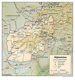
Afghanistan is in the middle of Asia. The country is landlocked and mountainous, and has most of the Hindu Kush mountains. There are four major rivers in the country: the Amu Darya, the Hari River, the Kabul River and the Helmand River. The country also contains a number of smaller rivers, lakes, and streams.
