Back Gloucestershire Afrikaans Gloucestershire AN Gleawcesterscīr ANG غلوسترشير Arabic Gloucestershire AST Gloucestershire BAN Gloucestershire BAR Глостэршыр Byelorussian Глостэршыр BE-X-OLD Глостършър Bulgarian
  | |

| |
| Geography | |
| Status | Ceremonial & (smaller) Non-metropolitan county |
|---|---|
| Origin | Historic |
| Region: | South West England |
| Area - Total - Admin. council - Admin. area |
Ranked 16th 3,150 km² Ranked 17th 2,653 km² |
| Admin HQ: | Gloucester |
| ISO 3166-2: | GB-GLS |
| ONS code: | 23 |
| NUTS 3: | UKK13 |
| Demographics | |
| Population - Total (2005 est.) - Density - Admin. council - Admin. pop. |
Ranked 25th 823,500 261 / km² Ranked 21st 575,400 |
| Ethnicity: | 97.3% White |
| Politics | |
Gloucestershire County Council http://www.gloucestershire.gov.uk/ Archived 2020-01-13 at the Wayback Machine | |
| Executive | Conservative |
| Members of Parliament | |
| Districts | |
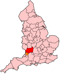
Gloucestershire (pronounced [ˈglɒstəʃə]; GLOSS-ter-sher) is a county in South West England. The county includes part of the Cotswold Hills, part of the flat fertile valley of the River Severn, and the entire Forest of Dean.
The county town is Gloucester, and other principal towns include Cheltenham, Stroud, Cirencester, and Tewkesbury.
Gloucestershire borders the county of Gwent in Wales, and in England the counties of Herefordshire, Worcestershire, Warwickshire, Oxfordshire, Wiltshire, Somerset and Bristol.
