Back ولاية قندهار Arabic Kandahar AST Qəndəhar vilayəti Azerbaijani قندهار ویلایتی AZB Кандагар (правінцыя) Byelorussian Кандагар (правінцыя) BE-X-OLD Кандахар (провинция) Bulgarian Kandahar BJN কান্দাহার প্রদেশ Bengali/Bangla Província de Kandahar Catalan
Kandahar
| |
|---|---|
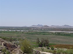
 View of Arghandab River Valley | |
| Nickname: Loy kandahar | |
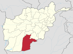
 Map of Afghanistan with Kandahar highlighted | |
| Coordinates (Capital): 31°00′N 65°30′E / 31.0°N 65.5°E | |
| Country | |
| Capital | Kandahar |
| Government | |
| • Governor | Zalmay Wesa |
| Area | |
| • Total | 54,022 km2 (20,858 sq mi) |
| Population (2012) | |
| • Total | 1,151,100 |
| • Density | 21/km2 (55/sq mi) |
| Time zone | UTC+4:30 |
| Area code | AF-KAN |
| Main languages | Pashto |
Kandahar or Qandahar (Pashto: کندھار or قندهار) (Persian: قندهار) is one of the largest of the thirty-four provinces of Afghanistan. It is located in southern Afghanistan, between Helmand, Oruzgan and Zabul provinces. Its capital is the city of Kandahar. There are about 913,000 people who live in the province.