Back مقاطعة كيواوني (ويسكونسن) Arabic Kewaunee County, Wisconsin BAR Киуаний (окръг, Уисконсин) Bulgarian কিৱাউনে কাউন্টি, উইসকনসিন BPY Kewaunee Gông (Wisconsin) CDO Kewaunee County CEB کاونێ کاونتی، ویسکۆنسن CKB Kewaunee County, Wisconsin Welsh Kewaunee County German Kewaunee County, Wisconsin English
Kewaunee County | |
|---|---|
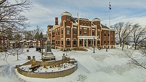
 Kewaunee County Courthouse | |
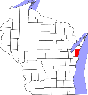
 Location within the U.S. state of Wisconsin | |
 Wisconsin's location within the U.S. | |
| Coordinates: 44°35′N 87°26′W / 44.59°N 87.44°W | |
| Country | |
| State | |
| Founded | 1859 |
| Seat | Kewaunee |
| Largest city | Algoma |
| Area | |
| • Total | 1,084 sq mi (2,810 km2) |
| • Land | 343 sq mi (890 km2) |
| • Water | 742 sq mi (1,920 km2) 68% |
| Population | |
| • Total | 20,563 |
| • Density | 60.0/sq mi (23.2/km2) |
| Time zone | UTC−6 (Central) |
| • Summer (DST) | UTC−5 (CDT) |
| Congressional district | 8th |
| Website | www |
Kewaunee County is a county in the U.S. state of Wisconsin. As of 2020, 20,563 people lived there.[1] Its county seat is Kewaunee.[2] Kewaunee County is part of the Green Bay Metropolitan Statistical Area.
- ↑ 1.0 1.1 "QuickFacts: Kewaunee County, Wisconsin". United States Census Bureau. Retrieved January 21, 2024.
- ↑ "Find a County". National Association of Counties. Retrieved 2008-01-31.