Back خيبر بختونخوا Arabic Hayber-Paxtunxva Azerbaijani خیبر پختونخوا AZB Хайбер-Пахтунхва Byelorussian Хайбэр-Пахтунхва BE-X-OLD Хайбер Пахтунхва Bulgarian खैबर पख्तूनख्वा Bihari খাইবার পাখতুনখোয়া Bengali/Bangla Khyber Pakhtunkhwa Catalan Khyber Pakhtunkhwa Province CEB
Khyber Pakhtunkhwa
صوبہ خیبر پختونخوا Afghania | |
|---|---|
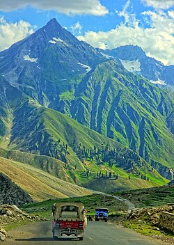
 Road to Naran Valley. | |
|
| |
 Location of Khyber Pakhtunkhwa in Pakistan | |
 Map of Khyber Pakhtunkhwa | |
| Coordinates: 34°20′35″N 72°10′48″E / 34.34306°N 72.18000°E | |
| Country | |
| Established | 1 July 1972 |
| Government | |
| • Legislature | Unicameral (?* seats) |
| Area | |
| • Total | 74,521 km2 (28,773 sq mi) |
| Population (2012) | |
| • Total | 20,215,000 |
| Time zone | UTC+05:00 (PST) |
| Official languages | Pashto · Panjabi |
| Website | khyberpakhtunkhwa.gov.pk |
Khyber Pakhtunkhwa (Urdu: صوبہ سرحد پاکستان) is a province in northwest Pakistan. The capital is Peshawar and it has a population of 14 million people and an area of 28,773 mi² or (74,521 km²). The province was created in 1901 during British rule when it was separated from a Punjab province of the British India Empire.[source?] A referendum was held in the North West Frontier Province on 2 July 1947. The majority of voters wanted to join with Pakistan, with only a very small number voting to join with India. The province became a part of Pakistan, because of this referendum.
Khyber Pakhtunkhwa is divided into 26 districts. There are 21 Settled Area Districts and 5 Provincially Administered Tribal Areas (PATA) Districts. The administration of the PATA districts is the responsibility the President of Pakistan and the Governor of Khyber Pakhtunkhwa.[1]
- ↑ "The Constitution". Government of Pakistan. Archived from the original on 2012-03-09. Retrieved 2010-04-27.

