Back محافظة اللاذقية Arabic محافظة اللاذقيه ARZ Gobernación de Latakia AST Əl-Laziqiyyə mühafəzəsi Azerbaijani لاذقیه اوستانی AZB Латакия (мухафаза) Bulgarian Governació de Latakia Catalan Latakia Governorate CEB پارێزگای لازقیە CKB Guvernorát Latákie Czech
This article needs to be updated. (July 2021) |
Latakia Governorate
مُحافظة اللاذقية | |
|---|---|
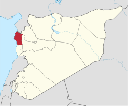
 Map of Syria with Latakia highlighted | |
| Coordinates (Latakia): 35°36′N 36°00′E / 35.6°N 36°E | |
| Country | |
| Capital | Latakia |
| Manatiq (Districts) | 4 |
| Government | |
| • Governor | Ibrahim Khodr al-Salem |
| Area | |
| • Total | 2,297 km2 (887 sq mi) |
| Estimates range between 2,297 km² and 2,437 km² | |
| Population (2014)[source?] | |
| • Total | 1,890,000 |
| • Density | 820/km2 (2,100/sq mi) |
| Time zone | UTC+2 (EET) |
| • Summer (DST) | UTC+3 (EEST) |
| ISO 3166 code | SY-LA |
Latakia Governorate (Arabic: مُحافظة اللاذقية / ALA-LC: Muḥāfaẓat al-Lādhiqīyah) is one of the fourteen governorates (provinces) of Syria. It is in western Syria, bordering Turkey. Its reported area varies in different sources from 2,297 km²[1] to 2,437 km².[2] The governorate population was 991,000 (2010 estimate). Members of the Alawite sect are the majority in the governorate, although Armenians, Turkmen, and Sunni Kurds form the majorities in the Kessab, Jabal Turkman, and Jabal al-Akrad regions respectively. The capital of Latakia had, by 2010 estimates, 400,000 inhabitants, 50% of whom were Alawites, 30% were Sunni, and 20% Christian.[3][4]
- ↑ "Syria: Governorates, Major Cities & Localities - Population Statistics, Maps, Charts, Weather and Web Information". citypopulation.de.
- ↑ "Syria Provinces". statoids.com.
- ↑ Dagher, Sam (25 June 2015). "Syria's Alawites: The People Behind Assad". The Wall Street Journal.
- ↑ "Latakia Is Assad's Achilles Heel". washingtoninstitute.org.