Back Alabama qraflıqlarının siyahısı Azerbaijani Countys in Alabama BAR Llista de comtats d'Alabama Catalan Rhestr o Siroedd Alabama Welsh Liste der Countys in Alabama German Κατάλογος κομητειών στην Αλαμπάμα Greek List of counties in Alabama English Anexo:Condados de Alabama Spanish Alabama maakondade loend Estonian Luettelo Alabaman piirikunnista Finnish
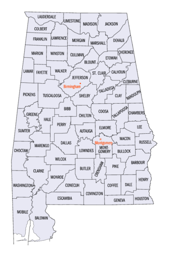
The U.S. state of Alabama has sixty-seven counties. The oldest is Washington County (created June 4, 1800) and the youngest is Houston County (created February 9, 1903).
Alabama was claimed by Spain, as Spanish Florida, and by England, as the Province of Carolina. The first permanent colony was made by the French on the banks of the Mobile River in 1702.
After the American Revolutionary War, West Florida south of the 31st parallel became a part of Spain while most of the rest was put in the Mississippi Territory. The territorial assembly established some of the earliest county divisions which have survived to the present. In 1817 the western part of the territory became the State of Mississippi and the remainder the Alabama Territory. The Alabama territorial legislature made some more counties.
Alabama became the 22nd state of the United States in 1819. The Alabama state legislature made more counties from former Indian lands as the Indian Removal Act took effect and settlers populated different areas of Alabama.
In 1820, Alabama had 29 counties. By 1830 there were 36, with Indians still occupying land in northeast and far western Alabama. By 1840, 49 counties had been created; 52 by 1850; 65 by 1870; and the present 67 counties by 1903.[1]
According to 2020 U.S. Census data, the average population of Alabama's sixty-seven counties was 74,989, while Jefferson County had the most people (674,721), and Greene County (7,730) had the least. The average land area is 756 sq mi (1,958 km2). The largest county is Baldwin (1,590 sq mi or 4,118 km2), and the smallest is Etowah (535 sq mi or 1,386 km2).
The Federal Information Processing Standard (FIPS) code, which is used by the United States government to uniquely identify counties, is provided with each entry. (In this system, St. Clair County is alphabetized ahead of Shelby County.) The FIPS code links in the table point to U.S. Census "quick facts" pages for each county.
- ↑ Foscue, Virginia O. (1989) Place Names in Alabama. Tuscaloosa, Alabama: University of Alabama Press. ISBN 0-8173-0410-X