Back مقاطعة ليتشفيلد (كونيتيكت) Arabic Condáu de Litchfield AST Litchfield County, Connecticut BAR Личфийлд (окръг, Кънектикът) Bulgarian লিটচফিল্ড কাউন্টি, কানেকটিকাট BPY Litchfield Gông (Connecticut) CDO Litchfield County CEB Litchfield County, Connecticut Welsh Litchfield County German Litchfield County, Connecticut English
Litchfield County | |
|---|---|
 | |
 Location within the U.S. state of Connecticut | |
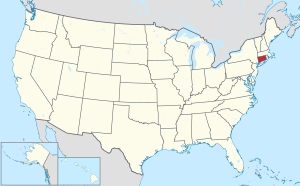
 Connecticut's location within the U.S. | |
| Coordinates: 41°47′N 73°14′W / 41.79°N 73.24°W | |
| Country | |
| State | |
| Founded | 1751 |
| Named for | Lichfield, England |
| Seat | none (since 1960) Litchfield (before 1960) |
| Largest city | Torrington |
| Area | |
| • Total | 945 sq mi (2,450 km2) |
| • Land | 921 sq mi (2,390 km2) |
| • Water | 24 sq mi (60 km2) 2.5% |
| Population | |
| • Total | 185,186 |
| • Density | 196.0/sq mi (75.7/km2) |
| Time zone | UTC−5 (Eastern) |
| • Summer (DST) | UTC−4 (EDT) |
Litchfield County is located in the northwestern corner of the U.S. State of Connecticut. As of the 2020 census, the population was 185,186.[1] The county has a total area of 2,446 km² (945 mi²). 2,383 km² (920 mi²) of it is land and 64 km² (25 mi²) of it is water. The total area is 2.61% water.
- ↑ 1.0 1.1 "Census - Geography Profile: Litchfield County, Connecticut". United States Census Bureau. Retrieved November 20, 2021.