Back Římské silnice v Británii Czech Römerstraßen in Schottland German Roman roads in Britannia English Strade romane della Britannia Italian


The Roman roads in Britain were, with Roman aqueducts, and the Roman army,[1] one of the most impressive features of the Roman Empire in Britain.
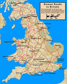
In Britannia,[2] as in other provinces, the Romans constructed a network of paved trunk roads to (surfaced highways). In their nearly four centuries of occupation (43 – 410 AD) they built about 2,000 miles of Roman roads in Britain. They are shown on the Ordnance Survey's Map of Roman Britain.[3] This is the most accurate and up-to-date layout of certain and probable routes that is available to the general public.
The pre-Roman Britons used unpaved trackways, including ancient ones running along the ridges of hills, such as the South Downs Way, now a public long-distance footpath. In contrast, most of the Roman network was surveyed and built from scratch, with the aim of connecting key points by the most direct possible route. The roads were all paved, to permit heavy freight-wagons to be used in all seasons and weather.
Most of the known network was complete by 180 AD. Its main purpose was to allow the rapid movement of troops and military supplies. It was also vital for trade and the transport of goods.
Roman roads remained in use as trunk roads for centuries after the Romans withdrew from Britain in 410 AD. Systematic construction of paved highways did not resume in England until the 18th century.
- ↑ In the 2nd century about 30 legions plus around 400 auxiliary units, totalling ~400,000 troops. Of these about 50,000 were in Britain.
- ↑ Originally, Britannia was a single province; at the end of Roman rule it was four provinces.
- ↑ "Map of Roman Britain, Ordnance Survey". Archived from the original on 2008-05-25. Retrieved 2010-08-13.