Back Ruhrgebied Afrikaans Ruhrgebiet ALS حوض الرور Arabic رور ARZ Rur regionu Azerbaijani Рурская вобласць Byelorussian Рурска област Bulgarian রুর Bengali/Bangla Ruhr (takad) Breton Regió del Ruhr Catalan
Ruhr Metropolitan Region
Metropolregion Ruhr | |
|---|---|
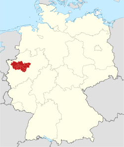
 map of the Ruhr metropolitan region within Germany | |
| Coordinates: 51°30′N 7°30′E / 51.500°N 7.500°E | |
| Country | |
| State | |
| Largest Cities | Dortmund Essen Duisburg Bochum |
| Government | |
| • Body | Regionalverband Ruhr |
| Area | |
| • Metro | 4,435 km2 (1,712 sq mi) |
| Highest elevation | 441 m (1,447 ft) |
| Lowest elevation | 13 m (43 ft) |
| Population | |
| • Metro | 5,172,745 |
| • Metro density | 1,646/km2 (4,260/sq mi) |
| Time zone | UTC+1 (CET) |
| GRP | 2007 |
| Nominal | € 136.3 billion[1] |
| Website | www.metropoleruhr.de |
The Ruhr Area (German: Ruhrgebiet) is an urban area in North Rhine-Westphalia, Germany. Many of the cities in the Ruhrgebiet used to have a lot of heavy industry.
The Ruhr Area is bordered by the rivers Ruhr River to the south, Rhine River to the west, and Lippe to the north. Southwest it borders the Bergisches Land.
The area has about 5.3 million inhabitants, and is part of the larger Rhine-Ruhr metropolitan area of more than 12 million people.
The Ruhr Area consists of the cities of Duisburg, Oberhausen, Bottrop, Mülheim an der Ruhr, Essen, Gelsenkirchen, Bochum, Herne, Hamm, Hagen and Dortmund and the rural districts of Wesel, Recklinghausen, Unna and Ennepe-Ruhr
- ↑ metropoleruhr.de
- ↑ highest: Wengeberg in Breckerfeld, lowest: Xanten