Back مقاطعة شرمان (كانساس) Arabic Sherman County, Kansas BAR Шърман (окръг, Канзас) Bulgarian শেরম্যান কাউন্টি, ক্যানসাস BPY Sherman Gông (Kansas) CDO Шерман (гуо, Канзас) CE Sherman County (kondado sa Tinipong Bansa, Kansas) CEB Sherman County (Kansas) Czech Sherman County, Kansas Welsh Sherman County (Kansas) German
Sherman County | |
|---|---|
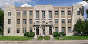
 Sherman County courthouse in Goodland (2012) | |
 Location within the U.S. state of Kansas | |
 Kansas's location within the U.S. | |
| Coordinates: 39°21′N 101°43′W / 39.35°N 101.72°W | |
| Country | |
| State | |
| Founded | September 20, 1886 |
| Named for | William Tecumseh Sherman[1] |
| Seat | Goodland |
| Largest city | Goodland |
| Area | |
| • Total | 1,056 sq mi (2,740 km2) |
| • Land | 1,056 sq mi (2,740 km2) |
| • Water | 0.2 sq mi (0.5 km2) 0.02% |
| Population | |
| • Total | 5,927 |
| • Density | 5.6/sq mi (2.2/km2) |
| Time zone | UTC−7 (Mountain) |
| • Summer (DST) | UTC−6 (MDT) |
| Congressional district | 1st |
| Website | www |
Sherman County (standard abbreviation: SH) is a county in the U.S. state of Kansas. In 2020, 5,927 people lived there.[2] Its county seat is Goodland.[3] Sherman County was created by the Kansas Legislature in 1873. It is named after General William Tecumseh Sherman.[4]
- ↑ "Welcome To the Official Sherman County Website". Sherman County, Kansas. Archived from the original on 2009-02-18. Retrieved 2012-11-04.
- ↑ 2.0 2.1 "QuickFacts: Sherman County, Kansas". United States Census Bureau. Retrieved October 3, 2023.
- ↑ "Find a County". National Association of Counties. Retrieved 2011-06-07.
- ↑ William G. Cutler's History of the State of Kansas, published 1883 by A. T. Andreas, Chicago, Il., http://www.kancoll.org/books/cutler/unorganized/unorganized-co-p1.html